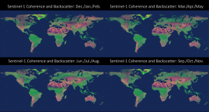
The University of Houston participates in delivering global synthetic aperture radar coherence dataset. Coherence is a parameter used for assessing SAR interferograms quality. It is represented by a real number varying from 0 to 1 calculated with the complex correlation coefficient. InSAR coherence can be used for several applications including forest mapping and land cover characterization. (Full Paper, AWS Sentinel-1 coherence dataset, Global coherence map at ASF, Press Release Earth Big Data)

Seasonal RGB mosaics of median VV 12-days coherence (red band), mean VH backscatter (green band), and mean VH/VV backscatter ratio (blue band). Colors are enhanced for visual effect, but not altered between seasons. Image Credit: Scientific Data.
